
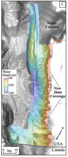
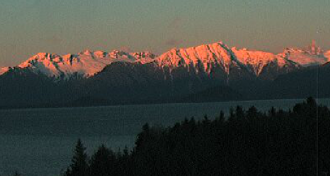
Researchers aboard the NOAA ship Fairweather collected multibeam bathymetric data in an area along the U.S. and Canadian international border in water depths ranging from 500 to more than 7,000 feet deep from April through July. (Image courtesy of the US Geological Survey)
As researchers completed mapping a fault line on the ocean floor off Southeast Alaska this summer, they’ve come to learn some surprising things about a seismically active part of the globe. Scientists expect more strong earthquakes from the Queen Charlotte-Fairweather fault but don’t think this type of geological feature would create a widespread tsunami.
The fault is marked by a giant groove along the sea floor, stretching hundreds of miles. It’s the boundary between two chunks of the earth’s crust. This type of fault is called a strike-slip, where the two tectonic plates slide along each other. In this case this Pacific Plate grinds slowly northward in relation to the North American Plate.
Scientists say this one is unusual because it is a very straight line and the two pieces of the earth are slipping at a relatively quick rate. Peter Haeussler, a research geologist with U.S. Geological Survey in Anchorage, said the plates are slipping about five centimeters, or two inches a year. That could be the quickest moving strike-slip fault in the world. Haeussler explained it also means frequent earthquakes.
“Well as the plates moves then strain accumulates and then eventually it’s released in an earthquake and so in general slow moving faults don’t produce earthquakes very often whereas fast moving plates, plate boundaries produce bigger earthquakes a lot more often,” he said. “So (that) helps to explain why there’s been so many magnitude seven plus earthquakes offshore Southeast Alaska and parts of British Columbia.”
The fault is often called the San Andreas of the north, after the more famous geological feature in California. It’s actually slipping at a quicker rate than the San Andreas. But less has been known about the one in Southeast Alaska because much of it is deep below the ocean’s surface.
Some prior mapping dated back more than 100 years. But in the past three years, researchers with the USGS and the National Oceanic and Atmospheric Administration have created a sonar image of the groove and the surrounding sea floor features. It covers 746 miles of the ocean bottom and nearly 58 hundred square miles. In places the sonar beams bounced off the bottom more than a mile below the sea surface.
NOAA does mapping of the sea floor for safe navigation and the data will be used to update nautical charts.
“This fault is fairly unique in the fact that it is so linear. And we could see the fault extremely well in our survey image,” said Meredith Payne, project manager for NOAA in the latest mapping work done on the agency’s ship Fairweather April through July.
Other work was done in 2015 and 2017 on different research vessels and also involved the Geological Survey of Canada and the Sitka Sound Science Center.
The fault has triggered six earthquakes of more than magnitude seven in the past century. The most recent were near Haida Gwaii in 2012 and offshore Craig in 2013. The USGS’s Haeussler said more of that size are expected.
“There’s no doubt that future big earthquakes will be exactly on this particular fault line,” Haeussler said. “It looks as if the motion will be purely side to side within, or as these earthquakes happen. And so for a question of tsunamis, just the movement of the sea floor would not generate a tsunami very effectively in future earthquakes.”
However, the threat of tsunami could come from a landslide that displaces water. That happened in Lituya Bay on the outer coast south of Yakutat in 1958. Haeussler said scientists looked for evidence of underwater landslides that could create a tsunami but found none.
“In particular one place we had wondered about a lot was Noyes Canyon, which is located kind of west of Craig,” he said. “And it’s kind of this unusual under water canyon that it’s the only large canyon that’s on the east side of this fault system and we had wondered oh could there have been some giant catastrophic under water land slide that made that canyon. But in data we just collected we found no evidence of that.”
They also looked at Lisianski Inlet in northern Southeast and found no evidence for seismic activity there. There same was true in Lynn Canal. “Again a super straight feature, it’s likely Lynn Canal and Chatham Straight were once part of what’s called the Denali Fault system,” Haeussler explained. “Some listeners may know that had a giant magnitude 7.9 earthquake in central interior Alaska. But it looks as if this part of that fault system going down Lynn Canal – Chatham Strait is not active. We found no evidence that for seafloor breaking in any way in an earthquake. We think that part of the fault system is now dead.”
There are some other spectacular features that showed up in the images. For instance, on the sea floor west of Elfin Cove, two parts of an undersea glacial valley formed over 17,000 years ago are offset almost a kilometer because of the movement of the plates. Besides nautical charts, the data will be used to update the state’s seismic hazard map.
Here’s a link to an interactive map created with this ocean floor data. In instructions from Meredith Payne, physical scientist and project manager in the hydrographic surveys division of NOAA’s office of coast survey, she recommends “scrolling down and choosing Alaska under the regions and then select the first bullet in the left-hand-side menu. That will reveal the West of Prince of Wales project region that contains the Queen Charlotte Fault map. Sometimes you need to zoom in and out a couple of times to get the image to display. Clicking in the image will reveal popups with project and depth information. Again, they are preliminary data that have not yet gone through the quality control workflow, and should never be used for navigation,” Payne writes in an email.


