
Petersburg High School students report another successful trip into the LeConte Bay on the mainland near Petersburg, to survey the southernmost tidewater glacier in the northern hemisphere. This is the 33rd year for the high school’s LeConte Glacier survey and the amount of research and knowledge about the ice mass continues to expand. This year more students are looking into different aspects of the position and characteristics of that glacier.
The program was started by PHS teacher Paul Bowen in 1983 . Since then a small group of students have been making an annual helicopter trip out to get a fix on the position of the terminus of the ice, where enormous bergs calve off the face into the bay. They’re flown into two points on the steep rocky walls of the mainland fjord, one on either side of the bay, 300 feet and 1000 feet above the ice berg choked water below
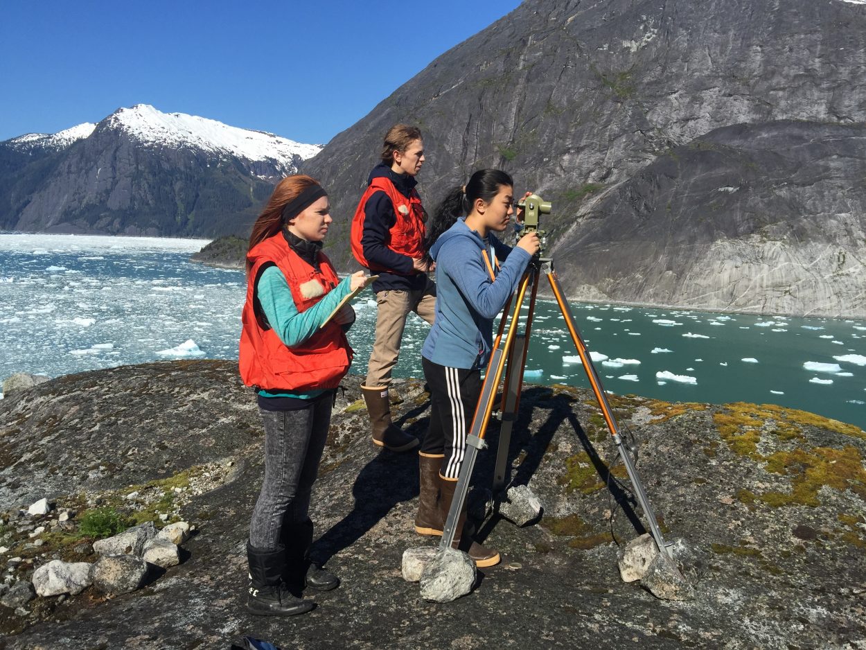
Alexandra Bless, Chauncy Sandhofer and Emma Chase survey points on LeConte Glacier this month. (Photo courtesy of Jon Kludt-Painter)
“It was really sunny,” said Nathaniel Lenhard, one of the juniors who made this year’s trip, in the second week of May. “We had a lot of fun. We took our points and we relaxed for a little bit and then we flew back,” Lenhard said. He and the other students were back in the classroom for an evening session in May, going back over the trigonometry needed to calculate the position of survey points recorded this year.
Science teacher Victor Trautman took over the program from Bowen in the 1990s and he tells the students it took him about three years to get the math down from Bowen before he felt comfortable teaching it to others. This year he has two other teachers in the class, math teacher Tommy Thompson and technology teacher Jon Kludt-Painter. They made the trip with the students this year and will be taking the class over from Trautman. That made this year’s trip a little different.
“It all went well but a little more responsibility on us because we were the most experienced going out there,” said senior Chauncy Sandhofer, the only senior in the group. It was his second year to do the survey and he thought the appearance and position of the glacier did not change too much from 2015. “No it hadn’t changed much, not too much no,” said Sandhofer. “I was on the same side of the glacier too. It was just almost like last year.”
While teachers are teaching each other, the older students in the class are helping a few younger students who will be making the trip in future years. And the program means a lot of work for the students, not just a sightseeing trip out to the ice. Students spend their lunchtime, once a week, out on the streets around the high school working with the surveying equipment they take out to LeConte Bay.
Another junior, Izabelle Ith, thinks giving up two year’s worth of her Wednesday lunchtimes to practice surveying was worth it. “Oh I was up on the north side and you look down at just the glacier and you can see there’s like a beautiful fjord directly across and it’s one of the most beautiful places I have ever been,” Ith said.
“It was definitely really rewarding I had a really great time,” agreed junior Alexandra Bless. “Like everyone has said the weather was beautiful. It was just really cool to see it up close.” Bless said that was her first time in a helicopter and one of the most exciting parts of the trip. “Yeah, getting in and out while it’s still running when you’re on the side of a cliff, it’s kinda scary,” she said.
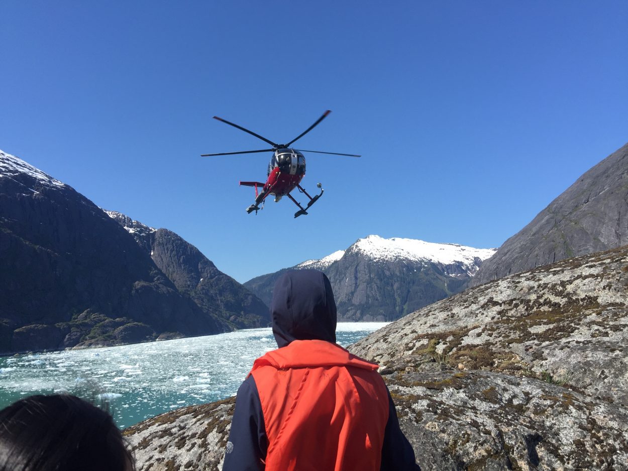
Temsco Helicopters prepares to pick up students in LeConte Bay. (Photo courtesy of Jon Kludt-Painter)
The annual survey depends on donated helicopter transportation by Temsco Helicopters and local pilot Wally O’Brocta. Despite the exciting ride, Bless said the students didn’t have any trouble getting the survey points they needed.
“Yeah it was a great view,” she said. “We got a perfect line right along the base of the glacier and we were able to pick I think about 12 points.”
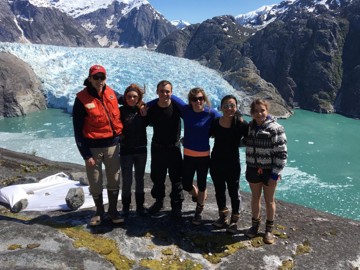
Chauncy Sandhofer, Alexandra Bless, Nathaniel Lenhard, Izabelle Ith, Emma Chase and Mariah Taylor made the trip to LeConte this year. (Photo courtesy of Jon Kludt-Painter)
Students are crunching the position of those 12 points and prepare to map out those spots compared to the data collected by generations before them. Prior students have mapped some big retreats of the ice mass in the 1990s, but since then the springtime location of the glacier’s terminus has not shown big changes in its location.
“We were out there exactly the same week as last year,” teacher Victor Trautman. “So keeping things constant we can say it’s pretty much the same place. Its face has changed. There’s a fast moving point that seemed to have broke off but that always does that in the summer anyway, maybe it just happened a little earlier. And the ice field is thinning we know that. So were gonna shoot, we’ve got some verticals, we’re getting some thicknesses above the water and from last year we know it is thinning, there’s not as much ice back up in the ice field.”
Trautman said that’s not the only new information being gathered by PHS students. “So we have six other students that are working with the University of Alaska Southeast, doing bathometry, current flow. They have National Science Institute funding to go do basically the rate at which the glacier is moving, the rate at which the water is traveling out and in and we now have three students in each one of those groups.”
For the second year, the program has also benefitted from high resolution satellite images of the glacier taken about the same time as the student visit. The images are provided by a former student who did the survey in 1991, Bob Davidson. He works for Geo North LLC, a company that provides geographic information systems and satellite data. The satellite image can be used as a basic check on the work the students are doing.
Trautman said the research on LeConte is important because of its location. “Well number one its in our backyard and number two its unique. There is no other tidewater glacier south of here until you get into Chile, so this is the southern-most tidewater glacier in North America, which should be a pretty good shall we say control compared to all the other glaciers because it’s the last one down here.”
The website for the program has a wide array of photos, videos, research and links about the glacier and the Stikine Icefield.


