
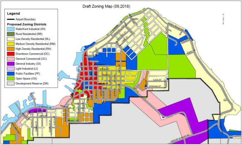
Many landowners in Petersburg could be seeing a change in the zoning for that land this year. That zoning spells out what’s allowed and what’s not on different types of land. Elected officials this winter and spring are reviewing a sweeping revision of the zoning map for land within the old city limits of Petersburg.
The proposed map implements new zoning classifications approved by the assembly late last year. There are new zones for areas that would be called waterfront industrial or light industrial as well as a new district for downtown commercial land. The development code passed by the assembly in December also would changes on land that isn’t seeing a big switch in zoning classification. For instance, owners of residential land can now look into detached second dwelling on their property, with size restrictions.
Petersburg’s planning commission held a hearing on the proposed map this month. One local land owner testifying was Harold Medalen.
“I think the whole thing needs to be revisited and I think it’s unconscionable that you haven’t sent a thing out to every property owner in town detailing exactly what the changes are to their zoning and what the allowed uses will be, because this has been presented as streamlining and allowing more uses and things like that,” Medalen said. “We don’t want tiny houses. We want to be able to continue to be able to use the property as we’ve been using it.”
The borough did send out a general letter to every land owner in service area one notifying them of the zoning map change and the process for reviewing the new map. Planning commissioners urged Medalen to bring up concerns about changes to specific land parcels. They also asked for concerns and opposition in writing so they could consider making changes for their next meeting in March.
Others testifying wanted assurances that they could continue to use their land as its currently zoned or if they’re permitted for a non-conforming use. Existing uses of land would be grandfathered in, and wouldn’t have to change because of the new zoning. The new map however will impact new uses of land in town.
Commission chair Chris Fry tried to explain some of the motivation for the new map.
“We’re trying to deal with where we have a lot of non-conforming uses and conflicting uses in the same area and trying to make it so that we’re not impacting neighbors much and everything else,” Fry said. “And that’s kind of the idea of some of the zoning change is to try and make it closer to what your property’s being used now.”
The new map also seeks to implement some of the recommendations from the borough’s 2016 comprehensive plan. Some single family residential land near downtown would change to medium density residential with smaller lot sizes allowed. Other residential land would be zoned for high density residential use, allowing for a variety of development including duplexes, townhomes, multi-family housing, mobile homes and manufactured home parks. The 2016 plan recommended changes to allow for more rental housing and affordable starter homes in town.
Other land in town that has been unclassified would be changed to industrial land, another need noted in the comprehensive plan. One of those parcels on the airport bypass road belongs to Jean Ellis. She asked the commission to leave her parcel without a zoning classification.
“At this time I don’t know what the highest and best use of that property will be at some point in the future and don’t believe that this is the time to make that decision,” Ellis told the commission.
The planning commission expects to vote on its recommendation on the proposed map, including any possible changes, on March 12. That recommendation goes to the borough assembly which will consider three readings of an ordinance. That review is scheduled to start April 1st with a final vote May 20th. The assembly can make future specific changes to any zoning with another three readings of an ordinance.


